2022 Spruce Beetle Activity
Spruce beetle activity has decreased dramatically. Only 48,800 acres of damage were recorded during aerial detection surveys, the least reported in a given year since 2015 and dramatically lower than the 193,550 acres mapped in 2021. More than 99% of all spruce beetle activity mapped statewide in 2022 was in Southcentral Alaska, where the ongoing spruce beetle outbreak is now estimated to be in its seventh year. The outbreak has affected more than 1.86 million cumulative acres of mixed spruce and birch forests since it was first documented in 2016. Like 2021, the outbreak remains most active in the northern Matanuska-Susitna Borough and the lower Denali Borough to the north and in the Chugach National Forest and near Soldotna and Kasilof on the Kenai Peninsula to the south. Activity has declined greatly in areas that were impacted most severely early in the outbreak. Visit the Alaska Forest Health Highlights 2022 StoryMap for more information about ongoing work with spruce beetle in Alaska.
2021 Spruce Beetle Activity
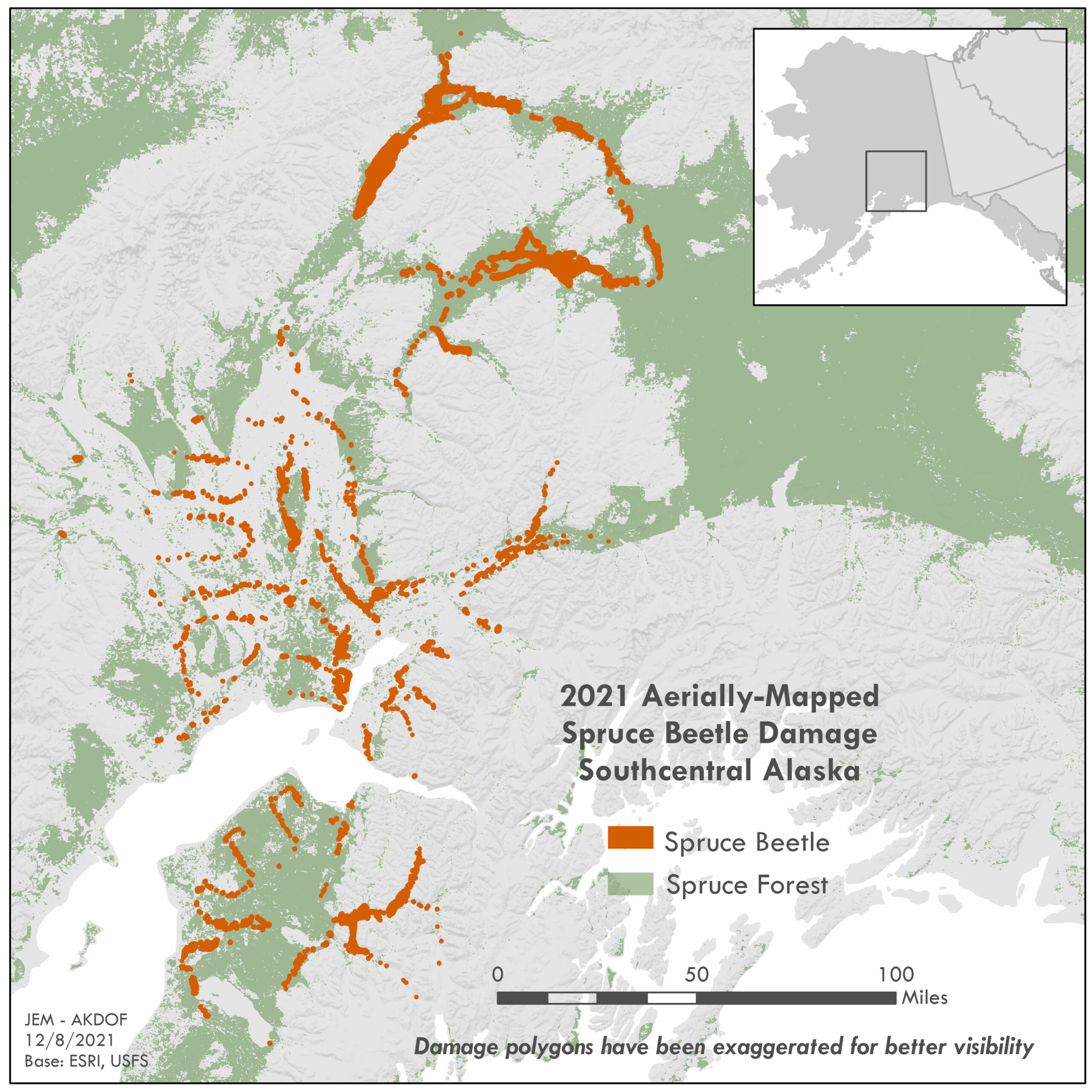
Spruce beetle activity was observed on approximately 193,500 acres statewide during aerial detection surveys in 2021. More than 98% of the activity mapped in 2021 was within Southcentral Alaska, where an ongoing spruce beetle outbreak is now estimated to be in its sixth year. The outbreak has affected at least 1.6 million cumulative acres of mixed spruce and birch forests since 2016, when it was first documented. In 2021, the outbreak was most active in the northern Matanuska-Susitna Borough, the lower Denali Borough, and around Cooper Landing, Kenai, and Soldotna on the Kenai Peninsula. Activity has declined in the areas that were impacted most severely early in the outbreak.
In areas that were initially impacted by the spruce beetle outbreak, such as the central and lower Susitna River Valley, a near exhaustion of susceptible white spruce is visible in many areas. Most spruce beetle activity in these areas is confined to black spruce and widely scattered residual small white spruce. In 2021, nearly 30,000 acres of black spruce forests were impacted within the outbreak area. Not all black spruce mortality observed in 2021 could be confirmed as solely caused by spruce beetle. During ground assessments, a small subset of recently killed black spruce showed signs of both spruce beetle and northern spruce engraver (Ips perturbatus), with neither being more likely the cause of the mortality than the other. Additional investigation is warranted in these areas.

2020 Spruce Beetle Activity
2020 Spruce Beetle Outbreak Update: Southcentral Alaska is estimated to be in the fifth year of a spruce beetle outbreak. The outbreak had affected at least 1.1 million cumulative acres of mixed spruce and birch forests through 2019, when a notable decline in active spruce beetle across the region was documented. Approximately 145,000 acres of spruce beetle activity was recorded in 2020, bringing the cumulative acreage affected by spruce beetle to be at least 1.2 million acres.
Matanuska-Susitna Borough, 2020 update: The spruce beetle outbreak appears to have expanded considerably in the Matanuska River Valley from the confluence with the Knik River upriver to at least Thirtymile Lake. Additional extensive damage was documented extending west from the Matanuska River along the southern edge of the Talkeetna Mountains, primarily north of the Little Susitna River, with pockets of recent spruce beetle damage scattered across the Wasilla and Meadow Lakes areas. Large pockets of recent spruce beetle damage were also documented along the Knik River near the Knik Glacier; this damage extended into the Municipality of Anchorage as well.
Municipality of Anchorage, 2020 update: With survey coverage in Anchorage typically limited, many of the spruce beetle-impacted forests observed included a mix of recently killed trees and those that had been killed earlier in the outbreak. This survey effort also confirmed that the impacts of the outbreak on the Municipality were much more extensive than previously known. The outbreak appears to be most severe in the portions of the Municipality from Joint Base Elmendorf-Richardson north to the Knik River, including all the major valleys in the Chugach Mountains south to the Ship Creek valley. Nearly all areas of the Anchorage Bowl are experiencing some level of spruce beetle activity. Recent spruce beetle activity was documented along many of the major creeks and some larger and more concentrated areas of damage were observed in east Anchorage, notably in Far North Bicentennial Park and the Campbell Tract, as well as in Kincaid Park in west Anchorage. Many pockets of recent spruce beetle activity were also observed in the Bird Creek valley along Turnagain Arm. Spruce beetle activity in this valley was unknown to surveyors prior to this survey effort and will be investigated in 2021.
Kenai Peninsula Borough, 2020 update: Two main areas on the Kenai Peninsula were prioritized for assessment of the spruce beetle outbreak, the Cooper Landing area and the Kenai/Soldotna area. Spruce beetle activity increased substantially in the Cooper Landing area in 2020, with pockets of damage observed along the Sterling highway and Kenai River from roughly Quartz Creek campground west nearly to Skilak Lake road; coverage farther west was limited by the image boundary. Spruce beetle-caused mortality was also scattered along the Russian River several miles upstream from its confluence with the Kenai River.
Spruce beetle activity continued to expand in the Kenai and Soldotna areas, with activity continuing in the Kenai National Wildlife Refuge as well as in the vicinity of the Kenai Spur highway from Soldotna to Kenai and west slightly farther than the airport. The damage appears equivalently extensive in the Soldotna vicinity, especially on the south side of the Kenai River, and continuing south nearly to Kasilof. An additional area of recent damage was observed south of Tustumena Lake in the Caribou Hills. On the southwestern tip of the Peninsula, recent spruce beetle activity was observed in Sitka spruce along Port Dick Creek, the Rocky River, and around Seldovia Lake; some damage was also mapped on Perl and Elizabeth Islands.
Each year the USDA Forest Service publishes a report of insect and disease activity in our forests based on surveys conducted jointly with the Alaska Division of Forestry & Fire Protection. Follow the link below to access Forest Health Conditions in Alaska (full reports, highlights sections, and damage maps) as well as interactive survey maps and StoryMaps (ArcGIS Online).
Click here to navigate to annual forest health reports and story maps

